


Ten Minutes From The Temple.
NH-52 (Jaipur–Sikar Highway), near Shree Shyam Dwar · Khatu Shyam, Sikar, Rajasthan. Pictured: Harshnath temple at sunset, 45 minutes away.
The address
NH-52, near Shree Shyam Dwar.
Khatu Shyam Ji · Sikar district · Rajasthan
On the Jaipur–Sikar highway (NH-52), near Shree Shyam Dwar, Khatu Shyam, Rajasthan. A full postal address and the exact project pin are awaiting confirmation from the developer; maps and directions open at Shree Shyam Dwar on NH-52.
- To Shree Shyam Dwar
- 2 min
- To Shree Khatu Shyam Mandir
- 10 min
- To Baori Railway Station
- 10 min
Drive times as listed by the developer; approximate, by road.
Where it sits
The map, in three dimensions.
The developer’s location map, built as a model you can explore. Select a place to fly to it.
Developer’s map Shown as a 3D model. Schematic, not to scale; the relief is decorative.
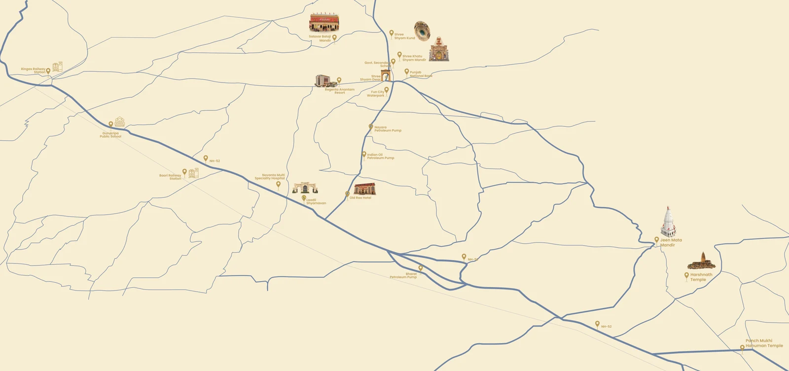
Developer’s map Schematic, not to scale. Select a numbered pin for details.
Nearby destinations
The places that bring you here.
10 min by road
Shree Khatu Shyam Mandir
The temple of Shyam Baba, in white marble. Its best-known festival is the Phalguna Mela in February–March.
2 min by road
Shree Shyam Dwar
The landmark gate the developer places the project beside.
45 min by road
Harshnath Temple
A 10th-century Shiva temple on Harsha hill near Sikar.
30 min by road
Jeen Mata Mandir
A hill temple in the Aravalli range of Sikar district.
Nearby facilities
Everything within reach.
From the developer’s listing and map. Approximate times by road.
Religious destinations
- 01Shree Shyam Dwar2 min
- 02Shree Khatu Shyam Mandir10 min
- 03Panch Mukhi Hanuman Temple10 min
- 04Shree Shyam Kund15 min
- 05Jeen Mata Mandir30 min
- 06Harshnath Temple45 min
Daily essentials
- 07Old Rao Hotel3 min
Education and healthcare
- 08Gurukripa Public School15 min
- 09Novanta Multi Speciality Hospital15 min
Transport and connectivity
- 10Baori Railway Station10 min
- —Jaipur–Sikar highway (NH-52)on it
Loading the map…
Getting here
Road, rail and what to ask.
- By road
- On the Jaipur–Sikar highway (NH-52).
- By rail
- Baori Railway Station, about 10 minutes by road.
- To be published
- Distances to Jaipur, Sikar and the nearest airport.
The map opens at Shree Shyam Dwar; the exact project pin is awaiting confirmation. It loads from Google.
Come and see the location.
Tell us when you would like to visit and we will call to confirm. You can also ask for the masterplan and price sheet.